TERRITORIES & PARTNERS


SHARED LANDSCAPES
︎ CONCEPT & CURATION
Caroline Barneaud
& Stefan Kaegi
︎ WITH PIECES BY


︎ PHOTO
︎ PRESS
︎ VIDEO
︎ MAPS & PROGRAM
︎ CONTRIBUTIONS
︎ AUDIO RECORDINGS
︎ DOWNLOAD PROJECT FOLDER
RESEARCH &
PEER LEARNING
︎ CASE BOOK
︎ ARTICLES
︎ LECTURE & TALKS
︎ EVENTS
︎ BEHIND THE SCENES

Théâtre Vidy-Lausanne
SwitzerlandInstalled in a building built by the artist and architect Max Bill for the 1964 National Exhibition, it now has four rooms and a foyer-bar open onto the beach at Vidy, with a view of Lake Léman and the Alps. For the artists, it offers an exceptional working environment coupled with a solid production structure and a technical team with multiple skills. For the spectators, it offers strong artistic experiences, prolonged during numerous encounters linking the works to the great questions that cross our society.
As a creative center for French-language theater in the heart of French-speaking Switzerland, the Théâtre Vidy-Lausanne takes advantage of the privileged location at the crossroads of Europe, to be a place open to the world, where Latin and Germanic theatrical and artistic cultures dialogue. Numerous collaborations are being developed with other theaters and cultural institutions in Switzerland and internationally.
The Théâtre Vidy-Lausanne is thus resolutely committed to an art form that is enriched by contrasts and differences and that confronts the realities of our time. At the same time, it multiplies the paths of access to the performing arts by varying the artistic languages - theater, dance, cinema, music, plastic arts - as well as the formats and the accompanying and mediating devices around the works.
A territory for Shared Landscapes | May/June 2023:
Chalet-à-Gobet
Shared Landscapes @ Théâtre Vidy-Lausanne
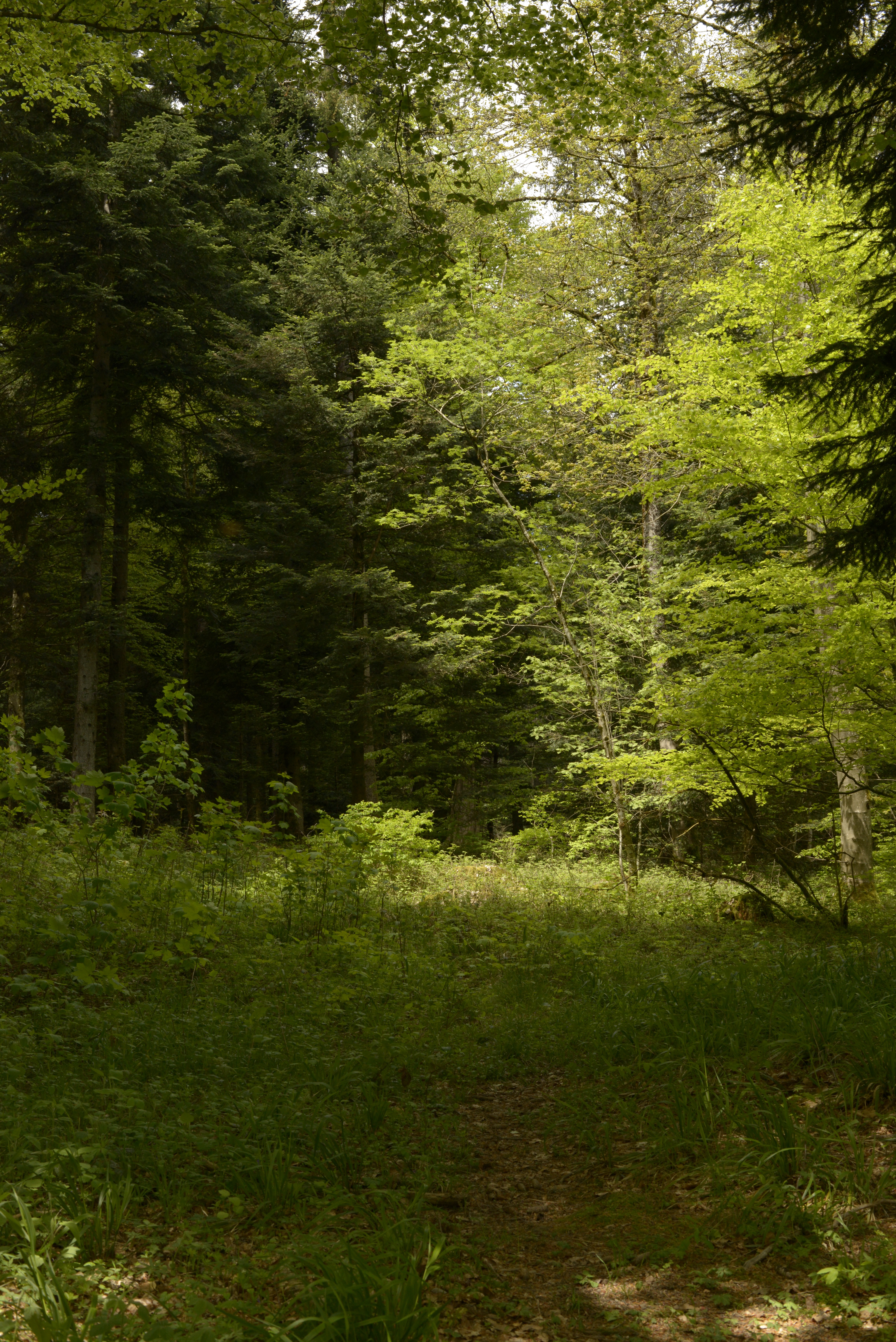
In this area, on the boundary between the city, the countryside and the forest, many local people and visitors come together: joggers, horse riders, forest rangers, skiers, farmers, wild and domestic animals...
The Jorat forest hill range is the largest single forest on the Swiss Plateau: a forest of fir and beech trees, although the spruce was also introduced over centuries of forestry. It lies on the watershed between the Rhone and Rhine basins and is criss-crossed by springs, streams and wetlands. The Jorat Peri-urban Nature Park was classified as a "nature reserve" by the Swiss Confederation in 2021. The protected area of 4.4 km² helps preserve the existing natural heritage and create favourable conditions for the biodiversity to evolve freely, which is in decline in lowland forests.
The Jorat forest hill range is the largest single forest on the Swiss Plateau: a forest of fir and beech trees, although the spruce was also introduced over centuries of forestry. It lies on the watershed between the Rhone and Rhine basins and is criss-crossed by springs, streams and wetlands. The Jorat Peri-urban Nature Park was classified as a "nature reserve" by the Swiss Confederation in 2021. The protected area of 4.4 km² helps preserve the existing natural heritage and create favourable conditions for the biodiversity to evolve freely, which is in decline in lowland forests.
This biodiversity includes in particular “saproxylic” species, including beetles and fungi, which are dependent on old or dead wood. These species represent about 25% of the forest fauna and flora and are essential to the natural life cycle of the forest.
The area comprises several different ecosystems: a large open area, cleared by the Cistercian monks of Montheron several centuries ago and where agriculture is still practised, the Mauvernay river, and the forest. The northern part of the plain is bordered by what is known as "le bois ballé", a forest in which industrial forestry was abandoned some thirty years ago: located behind a former shooting range, the wood is likely to contain many bullets, which makes it unsuitable for construction.
The area comprises several different ecosystems: a large open area, cleared by the Cistercian monks of Montheron several centuries ago and where agriculture is still practised, the Mauvernay river, and the forest. The northern part of the plain is bordered by what is known as "le bois ballé", a forest in which industrial forestry was abandoned some thirty years ago: located behind a former shooting range, the wood is likely to contain many bullets, which makes it unsuitable for construction.
This area of forest provides a glimpse of what the protected area of the Jorat Nature Park could become after several decades without human intervention.
The Mauvernay plain is farmed by Fabien Hunziker. This year he planted a cereal crop to feed his cows, and in June he mows the grass in the meadow, which will also serve as food for the cows in winter. This grass can no longer be mown if it has been flattened to the ground, so it is important to take care to use the marked paths and tracks: the forest floor and the fields are fragile and can be damaged by trampling, especially when it has rained.
The Mauvernay plain is farmed by Fabien Hunziker. This year he planted a cereal crop to feed his cows, and in June he mows the grass in the meadow, which will also serve as food for the cows in winter. This grass can no longer be mown if it has been flattened to the ground, so it is important to take care to use the marked paths and tracks: the forest floor and the fields are fragile and can be damaged by trampling, especially when it has rained.
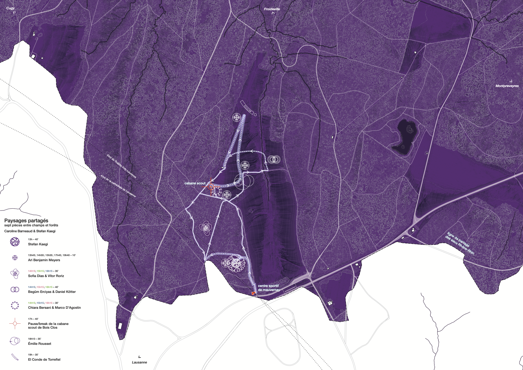
The Shared Landscapes map proposes three “disorientations” for perceiving the territory differently and conveying its geomorphological richness.
Disorientation no. 1
: Another catchment areaThe map highlights the Rhone-Rhine watershed and the Rhine catchment. The starting point of the show takes place precisely on this divide between the two basins. As you enter the forest and the clearing, you leave the territory of Lausanne’s water – which flows through Lake Geneva and the Rhone, ending up in the Mediter- ranean Sea – and enter the territory of the water that flows through The Three-Lakes, the Aare and the Rhine towards the North Sea.
Disorientation no. 2
: A clearing as ‘full’ rather than ‘empty’On official maps, as in our collective imagination, the forest resembles a dense mass and the clearing is the void that punctuates it. Here, however, it is the clearing that appears full of life and movement. The Mauvernay plain is a watery area located in the Jorat forest massif. It absorbs abundant rainfall which it releases in the form of countless springs and streams, as well as more than fifty wetlands offering favourable conditions for biodiversity.
Disorientation no. 3
: Anthropised natureOn the map, water, vegetation, human-made paths and the pieces of Shared Landscapes exist in dialogue. Behind an impression of nature lies a landscape shaped by the relationship between humans and the plain. Throughout the plain, hundreds of catchment points redirect the water to supply the surrounding area with drinking water. The area was cleared by the Cistercian monks of Montheron several centuries ago, and today Fabien Hunziker’s agricultural activity helps to maintain its contours. North of the clearing, the former rear area of a shooting range, the «bois ballé», unfit for construction, is now part of the protected area of the Jorat peri-urban Natural Park.