
TERRITORIES & PARTNERS


SHARED LANDSCAPES
︎ CONCEPT & CURATION
Caroline Barneaud
& Stefan Kaegi
︎ WITH PIECES BY


︎ PHOTO
︎ PRESS
︎ VIDEO
︎ MAPS & PROGRAM
︎ CONTRIBUTIONS
︎ AUDIO RECORDINGS
︎ DOWNLOAD PROJECT FOLDER
RESEARCH &
PEER LEARNING
︎ CASE BOOK
︎ ARTICLES
︎ LECTURE & TALKS
︎ EVENTS
︎ BEHIND THE SCENES

Théâtre Vidy-Lausanne
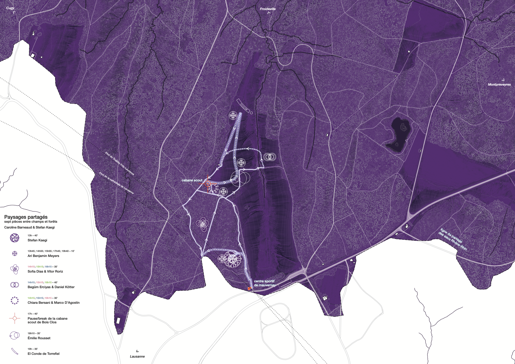
The Shared Landscapes map proposes three “disorientations” for perceiving the territory differently and conveying its geomorphological richness.
Disorientation no. 1
: Another catchment areaThe map highlights the Rhone-Rhine watershed and the Rhine catchment. The starting point of the show takes place precisely on this divide between the two basins. As you enter the forest and the clearing, you leave the territory of Lausanne’s water – which flows through Lake Geneva and the Rhone, ending up in the Mediter- ranean Sea – and enter the territory of the water that flows through The Three-Lakes, the Aare and the Rhine towards the North Sea.
Disorientation no. 2
: A clearing as ‘full’ rather than ‘empty’On official maps, as in our collective imagination, the forest resembles a dense mass and the clearing is the void that punctuates it. Here, however, it is the clearing that appears full of life and movement. The Mauvernay plain is a watery area located in the Jorat forest massif. It absorbs abundant rainfall which it releases in the form of countless springs and streams, as well as more than fifty wetlands offering favourable conditions for biodiversity.
Disorientation no. 3
: Anthropised natureOn the map, water, vegetation, human-made paths and the pieces of Shared Landscapes exist in dialogue. Behind an impression of nature lies a landscape shaped by the relationship between humans and the plain. Throughout the plain, hundreds of catchment points redirect the water to supply the surrounding area with drinking water. The area was cleared by the Cistercian monks of Montheron several centuries ago, and today Fabien Hunziker’s agricultural activity helps to maintain its contours. North of the clearing, the former rear area of a shooting range, the «bois ballé», unfit for construction, is now part of the protected area of the Jorat peri-urban Natural Park.
Shared landscapes cartographies:
#1 the Jorat natural park
Exhibition from May 14 to June 18 at the Théâtre de Vidy and everySunday at Chalet-à-Gobet during Paysages partagés + Lecture-performance and round table - Wed. May 31, 7pm, Théâtre Vidy Lausanne
A transdisciplinary collaboration that uses cartographic tools to reflect on the issues that underpin the concept of landscape and its appropriation by artists.
By Leila Chakroun, Amaranta Fontcuberta, researchers in environmental humanities, and Darious Ghavami, from the Competence Centre in Sustainability of the University of Lausanne. With the support of the City of Lausanne and the Jorat natural park.
Festival d’Avignon

Café des idées
@Cloître Saint-Louis
La matinale
8 July at 10:30With Pauline Bayle, Caroline Barneaud & Stefan Kaegi, Carolina Bianchi, Anne Teresa De Keersmaeker
Animated by Olivia Gesbert
Shared landscapes: creating within
the living
10 July at 5pm (in French)The concept of “shared landscapes” invites us to think about and question our relationship to real landscapes and to the living. What does it mean to inhabit the earth, not just as a purely human stage, but as a shared landscape? What role does the landscape play in theatre?
With Frédérique Aït Touati researcher and director, Caroline Barneaud and
Stefan Kaegi curators of Paysages partagés, Clara Hédouin director of
Que ma joie demeure, Marina Ezdiari CSR manager at Audiens
Moderated by Christophe Triau of the magazine Alternatives théâtrales
With Alternatives théâtrales and Audiens, with the support of European Union
Taking care of things and landscapes. Preservation, exhibition, performance. Preserved landscapes?
19 July at 11am (in French)Things and landscapes are two fragile elements, often forgotten and under attack. Artists and researchers discuss how they take into account landscapes and objects in their work, and how doing so has become an urgent need. The discussion will focus on the convergence of struggles, preservation, and exhibitions.
With Caroline Barneaud and Stefan Kaegi curator and curator of Shared Landscapes, Vera Martynov scenographer and artist (ESAA)
Animated by Antoine de Baecque director of SACRe, Barbara Turquier director of SACRe, Morgan Labar director of ESAA / With SACRe - ESAA
Berliner Festspiele
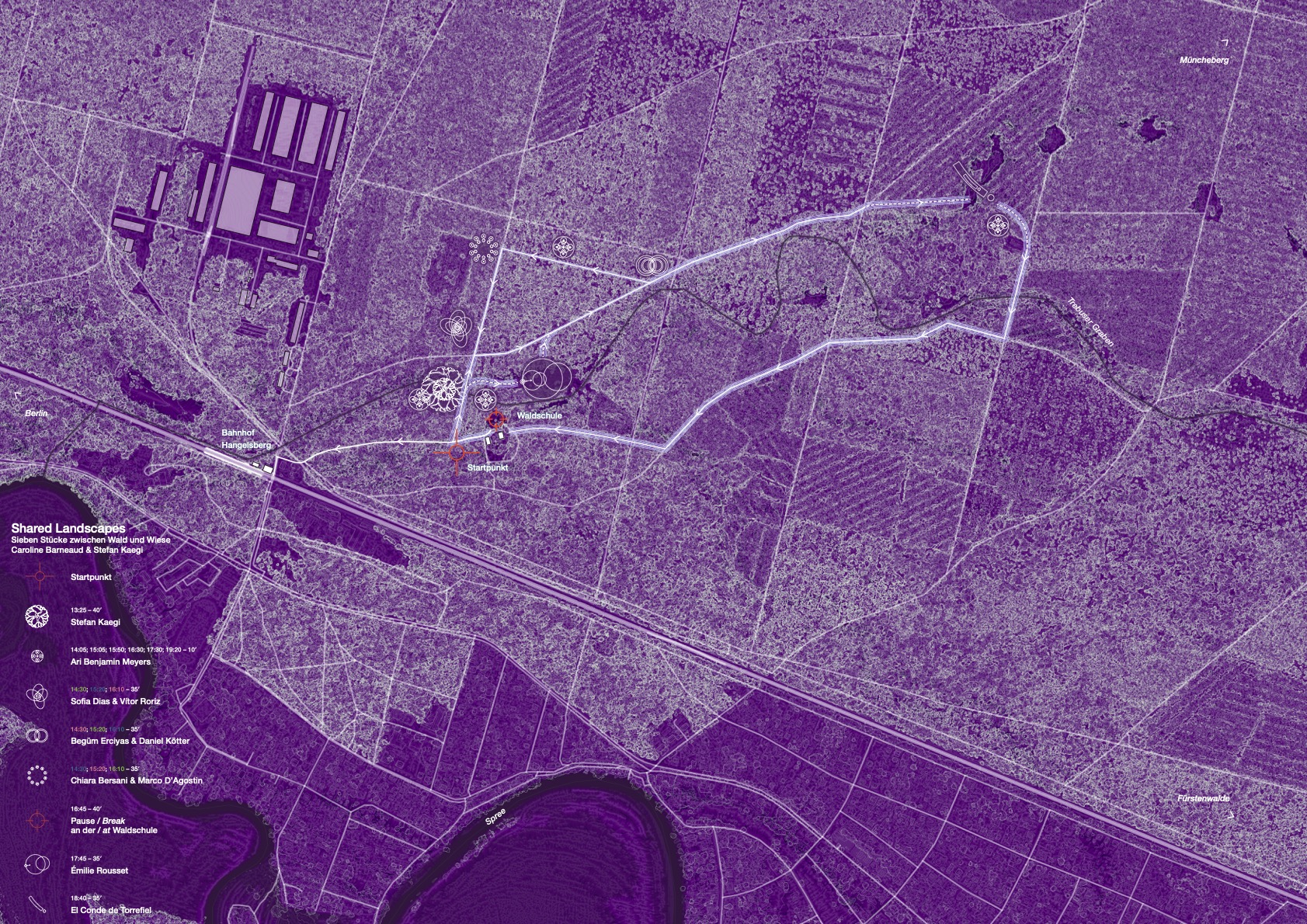
Hangelsberg Forest
Only a few train-stops away from Berlin, Hangelsberg is located not far from the border between city and countryside. North of the meandering river Spree and behind the historic railway station, there is a forest area that is shared by foresters, curious school groups and non-human inhabitants alike. This map suggests three re-orientations for this area that may shift our gaze in the Here and Now.
Only a few train-stops away from Berlin, Hangelsberg is located not far from the border between city and countryside. North of the meandering river Spree and behind the historic railway station, there is a forest area that is shared by foresters, curious school groups and non-human inhabitants alike. This map suggests three re-orientations for this area that may shift our gaze in the Here and Now.
Re-orientation I:
From glaciers to water courses to dried-out trenchesThe map shows an area surrounded by lakes and forests, whic belonged to the Berlin-Warsaw Glacial Valley and was create by meltwaters at the end of the last ice age. The past decades however, have left their mark on the landscape: In large parts o Brandenburg, the groundwater level has dropped. The Trebuser Graben (Trebus trench), which used to carry water decades ago has dried up: a consequence of increased water usage and former soil culture schemes like draining wetlands to render surfaces usable for agriculture and forestry.
Re-orientation II:
Stabilising combinations and relicts from former timesRetaining water within the landscape and stabilising forests by means of combining various species of trees is the future task. The area around the forest school is an example of a structured mixed forest that has long been made up of more than just pine trees. Other parts
of the forest, including the area around Stefan Kaegi’s piece, have been ‘disused’ for quite a while: The wood is no longer utilised and nature is left to its own devices. In the area’s immediate vicinity, there are several “Hutewald-Eichen” (oak trees in a pastoral forest), which are more than 300 years old. They are reminiscent of times when there was intensive woodland pasture, and such forests provided food fo livestock like sheep, pigs and cattle.
Re-orientation III:
Resin extraction and other tracesThe patterns in pine trunks around the piece by Begüm Erciyas and Daniel Kötter point towards a different kind of woodland utilisation. Extracting tree resin (German: “Harzung”) was mainly a matter of economic necessity, a way to secure self-sufficiency with the hel of replacement resources. Resin extraction was first undertaken during the First World War and continued after the Second World War until 1990, especially in the GDR. These (wo-)man-made traces complement the paths crossing the area. Generations of forester have been active here, working with the forest, developing it in
accordance with nature and preserving it for future generations.
Tangente - St. Pölten Festival

Projects as part of “Tipping Time” –
Climate Conference of Civil Society
May 9th to 11th, 2024, Sonnenpark St. Pölten:
Saturday, May 11th, 11:30 a.m. to 1:00 p.m.: Exploring the Landscape. A walk through Sonnenpark with scientists and artists from the “Performing Landscape” project (in English).
Meeting point: Mobile City Lab.
Admission is free, but the number of participants is limited. Please register at the reception from 10:00 a.m.
With Leila Chakroun, Amaranta Fontcuberta, Karin Harrasser, Emanuele Regi, Joana Braga, Maja Simoneti, María Auxiliadora Gálvez, Caroline Barneaud, and Stefan Kaegi.
Saturday, May 11th, 2:00 – 3:30 p.m.:
Winds of Change: Climate Policy Turbulence. Lecture by Karin Harrasser (cultural scientist) followed by a discussion with Caroline Barneaud and Stefan Kaegi at the Mobile City Lab.
Zona K & Piccolo Teatro di Milano
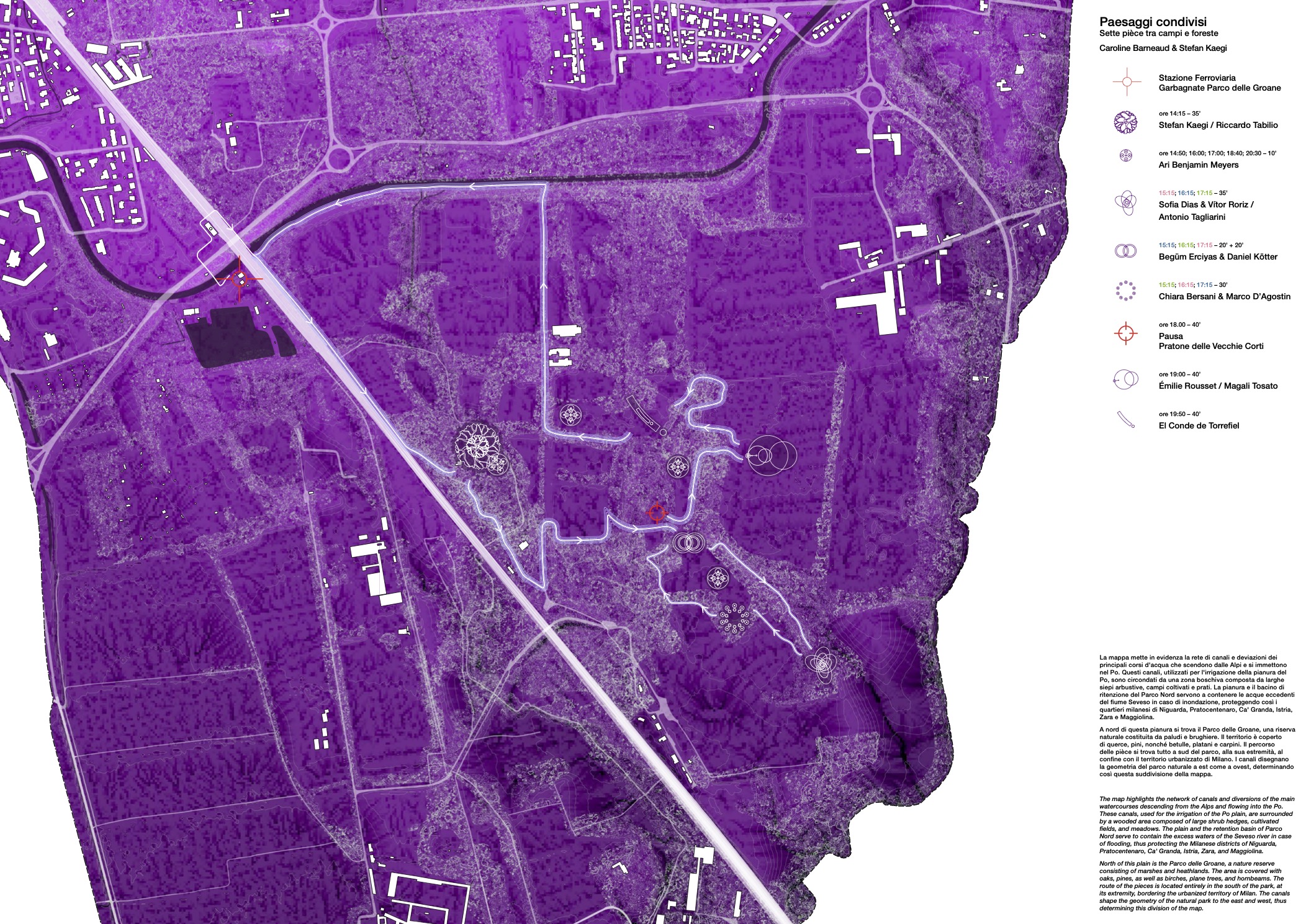
The map highlights the network of canals and diversions of the main watercourses descending from the Alps and flowing into the Po. These canals, used for the irrigation of the Po plain, are surrounded by a wooded area composed of large shrub hedges, cultivated fields, and meadows. The plain and the retention basin of Parco Nord serve to contain the excess waters of the Seveso river in case of flooding, thus protecting the Milanese districts of Niguarda, Pratocentenaro, Ca' Granda, Istria, Zara, and Maggiolina.
North of this plain is the Parco delle Groane, a nature reserve consisting of marshes and heathlands. The area is covered with oaks, pines, as well as birches, plane trees, and hornbeams. The route of the pieces is located entirely in the south of the park, at its extremity, bordering the urbanized territory of Milan. The canals shape the geometry of the natural park to the east and west, thus determining this division of the map.
ENCOUNTERS: THE LANDSCAPE ON STAGE
curated by Emanuele Regi and Francesca Serrazanetti#1 VOCI: CREANDO PAESAGGI CONDIVISI
The relationship between theater and landscape is ancient but subject to continuous reinventions. Inside and outside the city, the invisible becomes evident before the spectator's gaze, guided by the lens of art. The Shared Landscapes project offers an overview of possibilities and visions by placing the landscape as the subject of theater, moving beyond the conventional stage- audience relationship. In dialogue with the involved artists, the encounter delves into the processes of approaching artistic creation in the relationship between space and performative devices, between the construction of community and a shared European idea of landscape.
7 giugno 2024 ore 18.30
c/o Chiostro Nina Vinchi, via Rovello 2, Milano
With Francesca Serrazanetti (Politecnico di Milano / Stratagemmi), Emanuele Regi (PhD candidate - Università di Bologna) in dialogue with the project's artistic curators: Stefan Kaegi and Caroline Barneaud and some of the artists involved.
ENCOUNTERS: THE LANDSCAPE ON STAGE
curated by Emanuele Regi and Francesca Serrazanetti#2 MAPPE: IL VALORE DEL PAESAGGIO TRA TEATRO, NATURA E ARTIFICIO
An archive of signs, a palimpsest of traces, the landscape elude a single definition. At the boundary between city and countryside, between natural and artificial, at the intersection of theater and social ritual, between human and non-human communities, the Shared Landscapes project is an opportunity to discuss key issues regarding the relationship between spaces and inhabitation. Starting from theater, it explores new ways of looking at one's territory and its value.
11 giugno 2024 ore 18.30
c/o Biblioteca Comunale di Bollate, Via Carlo Alberto dalla Chiesa 30
With Francesca Serrazanetti (Politecnico di Milano / Stratagemmi), Emanuele Regi (PhD candidate - Università di Bologna) in dialogue with Arch. Giuseppe Brollo, Prof Antonio Longo (Politecnico di Milano), Ente Parco delle Groane.
Culturgest

The reference point of the Shared Landscapes Map is the level of the Rio da Mula dam, which supplies water to the municipality of Cascais. Everything below this level is visible, while anything above disappears from the map.
Shared Landscapes unfolds in Quinta do Pisão and oscillates around this reference point.
Mladi Levi Festival

The map of Shared Landscapes focuses on Rožnik, which dominates Ljubljana and faces towards Castle Hill and Ljubljana Castle. The water flowing through this territory belongs to the Ljubljanica watershed, while in the north, the territor that is not visible marks the transition to the Sava watershed, one of the main tributaries of the Danube.
Koseški boršt
Koseški boršt is a forest below Rožnik in Ljubljana, stretching between the Rožna dolina
and Koseze. Večna pot cut this area off from the rest of the hilltop urban forest and the
city park. Together with forest clearings and remnants of the cultural landscape, this
gently undulating forest landscape opens out to the west and the city outskirts, but it is
also part of the central urban park area, which is directly connected to the very centre
of the national capital.
After the war, the authorities built the Pioneer Railway and the Biotechnical Faculty in Koseški boršt, and today the forest, together with the Path of Remembrance and Comradeship, is a popular promenade for city dwellers to catch the last rays of the afternoon sun.
Koseški boršt is an integral part of the urban forest in the Tivoli, Rožnik and Šiška Hill Landscape Park, as well as a part of the city’s cultural landscape that extends like a green wedge from the hinterland to the centre of Ljubljana. From the city centre at the Tromostovje Bridge, it is a good three kilometres air distance to Koseški boršt, and most of the way leads through the city park and forest area. In its own way, Koseški boršt is also a building block of the city’s identity. Apart from the Ljubljanica River, it is the wooded slopes of the Castle Hill with its castle and the varied forest and parkland of the City Park, which acts as a protected nature and cultural heritage area, that create Ljubljana’s identity to the greatest extent.
The name Koseški boršt is of historical origin. The kosezi (free peasants) appeared during
the Alpine Slavic colonisation of the area as individuals with the right to use their land
freely, without feudal rights. They were mostly farmers and soldiers, and for a while they
even had the right to their own duke. The word “boršt” comes from the German word for forest (der Forst) and indicates that in those times the area was governed by rulers of
Austrian origin. Records show that they had a great understanding of the needs of the
townspeople.
For a long time Ljubljana had no forests of its own, and the Austrian dukes therefore urged the regional governors to allow the citizens of Ljubljana to transport and collect firewood and wood from the woods and forests around the city, as had always been the custom.
In Koseški boršt, as in all other Slovenian forests, the right of free use of the forest and the right to collect forest fruits have been preserved to this day, while the economic use of timber is the exclusive right of the owners.
In the past, the local authorities had the wisdom to protect the area from construction development and, through consistent spatial planning, to create the basis for the unique structure and appearance of the urban landscape and the central city park, which extends over an area of 459 hectares. As early as the 19th century, the authorities recognised
the great importance of the proximity of the forest for the inhabitants and, in the course
of planning the expansion and development of the city, began to carefully protect the forest area on the Rožnik and Šiška Hill from construction and to preserve it for public use.
In this way, the authorities, together with the property owners, who also opened their gardens for public use, began the development of an outstanding cultural heritage and today’s Tivoli, Rožnik and Šiška Hill Landscape Park. As a result, people, animals and plant seeds are still able to move freely between the city centre and its outskirts, enjoying the free use of open public spaces, the cultural landscape of the hinterland and the high quality of life.
Koseški boršt is a mixed forest, partly flat and wetland, growing on a predominantly
siliceous base with acid brown soils. The tree layer is dominated by beech, oak, chestnut,
sessile oak, spruce, fir and Scots pine, as well as rowan both as a tree and a shrub.
The shrub layer is characterised by buckthorn and bilberry, and the herb layer is very rich. The area is home to many birds and other animals, including small carnivores, deer,
foxes and badgers.
Ljubljana’s Večna pot road cut through the forest landscape of Koseški boršt a long time ago and, despite the development of activities in the surrounding area, nature has been preserved in a relatively good condition in much of this slightly wet forest area. Over time, new paths and trails have been added to the existing ones, helping to ensure that the area remains largely open to those who wish to connect with nature in the city and to explore the attractions of the urban surroundings, such as the views of the deer grazing in the forest glades and the water and shore area of the Koseški bajer pond.
Koseški boršt is owned by several different private owners, whose exploitation of the forest is guided by the forest management plan and the management of the landscape park. At the same time, the area is also subject to cultural heritage protection regulations. The management of the use and maintenance of the urban forest thus follows both the principles of free use laid down in the Forest Act and the negotiation that takes place between the landowners and the representatives of the various public interests presen in this valuable urban area.
Temporada Alta - Girona
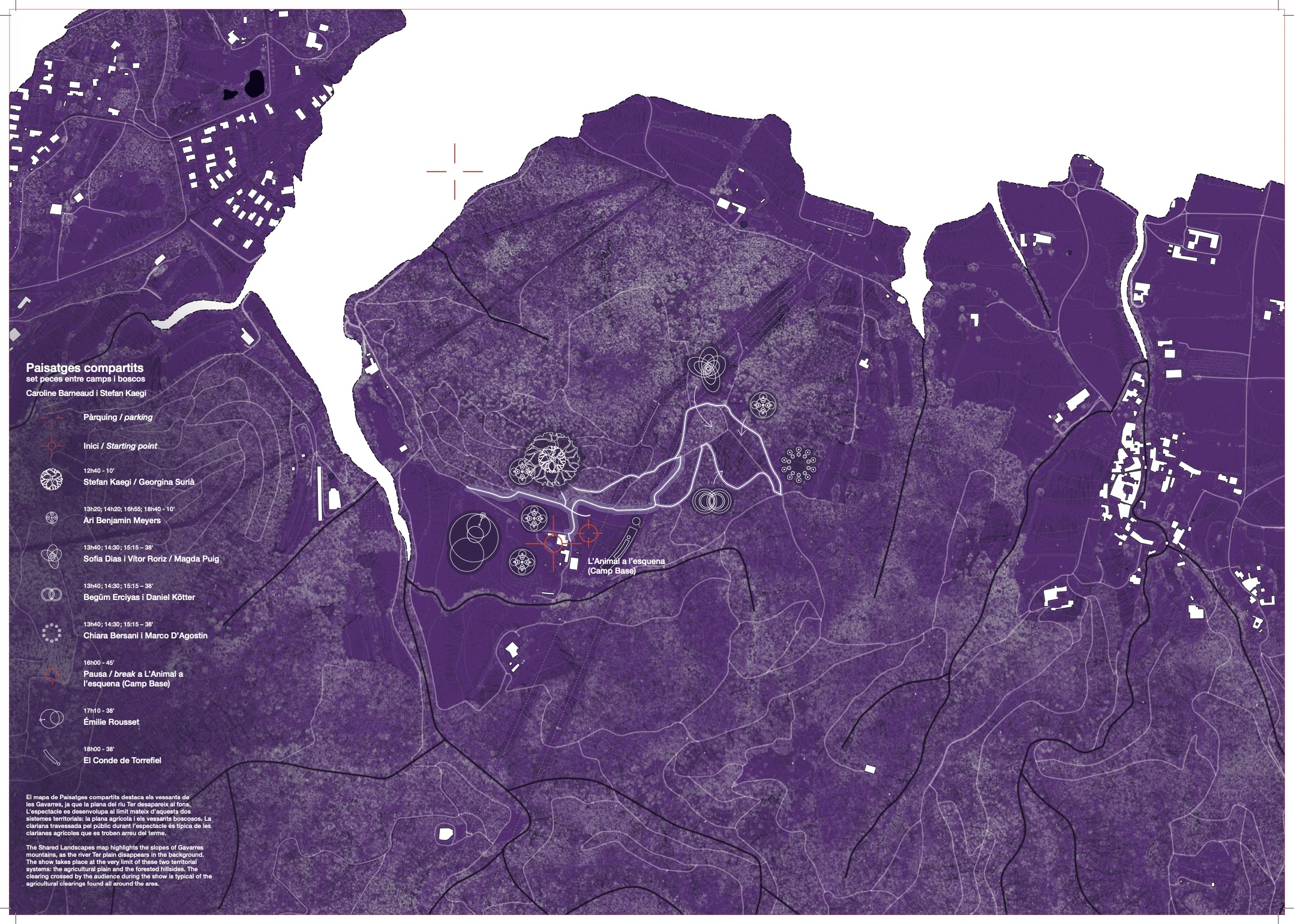
The Shared Landscapes map highlights the slopes of Gavarres mountains, as the river Ter plain disappears in the background. The show takes place at the very limit of these two territorial systems: the agricultural plain and the forested hillsides. The clearing crossed by the audience during the show is typical of the agricultural clearings found all around the area.
L’animal a l’esquena, Celrà i les Gavarres
Shared Landscapes takes place in Celrà, specifically at L’Animal
a l’esquena, a space coordinated by artists María Muñoz and Pep Ramis. It is a residence and experimentation center for creative groups and diverse projects. It is set within a private outdoor estate amidst a rich natural mountain environment: Les Gavarres.
a l’esquena, a space coordinated by artists María Muñoz and Pep Ramis. It is a residence and experimentation center for creative groups and diverse projects. It is set within a private outdoor estate amidst a rich natural mountain environment: Les Gavarres.
Celrà and the Gavarres area are a mix of medieval heritage with
castles and towers and natural landscapes between the Ter river and
the mountain, with deep industrial roots through their limestone kilns,
tile manufacturers, and iron mines. The region is surrounded by gently
rolling hills containing metamorphic rocks: slate, schist, and granite. It
is an exceptional and unique landscape, a green area for the Gironès
region, with countless animal and plant species that enrich the
natural heritage of the area and make it an idyllic place with a great
variety of landscapes.
This region was declared a Natural Area of Interest in 1992. The
highest point above sea level is the Puig de la Gavarra, at 537 meters,
but it is generally not an area of steep hills. The landscape is almost
entirely covered with forests, with some fields and farmhouses.
The flora of Les Gavarres is varied and rich. Holm oak and cork oak forests predominate, accompanied by pines and oaks in higher areas. Mediterranean shrubs, with species such as heather, strawberry
tree, and mastic, cover the underbrush. Additionally, aromatic plants like rosemary and thyme abound. This vegetation mosaic creates a unique landscape, vital for the conservation of the local biodiversity.
Sharing landscapes· Conference and round table 9/10 at 7 p.m. Centre Cívic La Mercè
With Maria Auxiliadora Gálvez (Ph.D. in architecture and landscape engineer. Member of the scientific committee of Shared Landscapes), Martí Franch (landscape architect, agricultural technical engineer and col·laborer of the scientific committee of Shared Landscapes, Stefan Kaegi (creator and curator of Shared Landscapes and member of the German company Rimini Protokoll), Caroline Barneaud (creator and curator of Shared Landscapes) and Tanya Beyeler and Pablo Gisbert from El Conde de Torrefiel.
Conference by Maria Auxiliadora Gálvez and round table with the rest of the participants. A talk to understand how we can design our cities and, at the same time, understand the ecological dynamics of landscapes taking into account the practices and bodies that inhabit them. As performing arts and landscape (be it urban or rural) they have points in common and mutual learning.